Where: Hancock Mt.
When: 7/10/2019
With: Solo
On the list of New Hampshire's 48 4000+ foot peaks, several are nearly always climbed in pairs. After a long and difficult approach to the first summit, the next one is a fairly short distance further, and separated by close to the minimum elevation change (200 feet) required to qualify as a separate peak. So it's something of a no-brainer to run over and claim the second summit.
That said, there are three of these pairs (the Twins, the Kinsmans, the Hancocks) where, for various reasons, I only summited one of each pair. In the case of the Hancocks, I attempted a bushwhack to another peak after climbing North Hancock, and never got the South peak. So, 32 years later, I was finally completing the Hancock Loop.
I was out the door just before 6AM and at the parking lot around 8:30. It was my first time on the Kancamagus Highway in 16 years, but Lincoln looked about the same as I passed through and made my way to the parking area at the hairpin turn. There were 2 other cars in the lot when I arrived, with the occupants of one still packing up as I headed out. We said we'd see each other on top, but we never crossed paths again.
 |
| Parking lot trail info |
 |
| Trail head on Kancamagus Highway |
The Hancock Notch trail was easy walking, and I tried to take advantage of it to make the best time I could.
 |
| Hancock Notch trail |
 |
| Hancock Notch trail |
I soon arrived at the Cedar Brook trail, where I encountered a large group of teen boys heading in the opposite direction. Full backpacks and gear, so I assume they'd been out overnight. A lively, talkative crew. They'd be the last folks I'd see for awhile.
 |
| Cedar Brook trail |
A short while later I was at the start of the Hancock Loop trail. The area around the junction was cleared out...presumably a camping spot. I'd been walking for 50 minutes and had covered 2.5 miles. I left the Cedar Brook trail and began my climb toward the Hancocks.
 |
| Hancock Loop trail start |
The trail was still not especially steep, so I continued to push the pace on the approach portion of this hike. I did stop briefly though to check out a possible camping spot along the stream next to the trail. The spot was on the other side of the stream, offering a bit of isolation from the trail. Maybe another day.
I arrived at the Loop junction right at 10:00, and took my first real break of the hike before starting toward the North peak. The trail began with a steep descent into a dry gully, and I grumbled about giving up altitude, but it was a short distance to the bottom and the start of the real climbing.
The guidebooks say the climb begins at a moderate grade, but as far as I was concerned it was all straight up, with rough, loose footing. In contrast to my earlier pace, I found myself moving slowly and taking frequent breaks. At each break, I'd look up the trail, pick a destination about 50 feet further along, and head to that spot for my next rest.
 |
| Climb up to North peak |
Part way up, I met another hiker heading down. He appeared to be about my age. He said he did the loop in the opposite direction than me because he hated the initial descent. We parted, and I kept on my slow climb. I found myself hoping the trail would eventually ease a bit (vs. going straight up right to the summit) and indeed it did. After a turn, it began going across the slope, offering views to the south.
 |
| View approaching North peak |
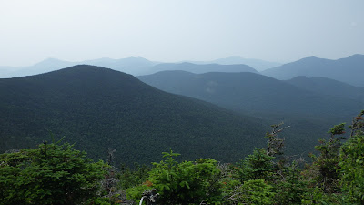
Then finally, I was at the summit. It had taken about 45 minutes to climb 0.7 miles. The trail ended at a sign pointing the way to the South peak in one direction, and an overlook in the other. I headed to the overlook, for the views and a food break. The views were indeed grand (though hazy, due to wildfires in Canada), but the food break was hampered by a cloud of voracious mosquitoes. Bugs hadn't been a problem until this point, but they certainly were now. I took a few pictures, ate some snacks, and tried (unsuccessfully) to get cell service to send a text home, but the bugs were too bad to linger and I was quickly moving again.
 |
| North peak summit |
 |
| North peak view |
 |
| North peak selfie |
I got a short distance along the ridge link before I realized I hadn't seen a summit sign or marker. The trail was definitely descending, so perhaps I'd missed it. I left my pack and ran back to the trail sign, but decided that there was in fact no marker and returned to my pack and my walk.
 |
| Pack on the ridge trail |
Since I was finally on a steady descent, I retrieved my hiking poles from my pack. I find they provide much-needed stability, and save my thighs from burning out. The trail dropped off the peak and into a small col. To the left I could see the summit of Mt. Carrigain. I was reasonably sure this was the spot where I began my bushwhack 32 years ago, so I figured that from this point on I was on new (to me) trail.
The path climbed a bit, then dropped again, descending to cross a wet area on bog bridges before climbing again.
 |
| Bog bridge on ridge trail |
I met up with another older hiker in this area, heading the opposite way, and we exchanged greetings. The trail continued to climb easily through a pretty woods, until it appeared I was at the top. The path turned sharply and started down. Once again, I walked a short way before thinking I'd missed a summit marker and returning back the way I'd just come. This time there wasn't even a trail sign that might indicate a summit, so I just went to what seemed to be the highest point on the trail, figured that was it, turned around and continued on.
[A little detour in this story now. The high point I was on is sometimes noted as Middle Hancock. It's part of the ridge line connecting Hancock and Carrigain, which also marks the town line between Lincoln and Livermore. That's the ridge line I was attempting to follow 32 years ago. I still have the map I used then, and the town line is clearly marked. I would have used that info to begin my bushwhack at this point, not at the small col I'd passed earlier. I was mistaken in both my earlier write-up and in my recollection of the hike.]
As I discovered later, the point I just left was not the South summit. The trail continued to drop, but then began another climb and soon I was at the true South peak summit. At last! It was about 11:50. Like the North peak, there was no summit marker (that I could find), but the trail sign served to mark the spot. Also like the North peak, the mosquitoes were out in force. Still, I stayed a while, exploring the summit (there are a few campsites there), taking pictures from the overlook, and eating my lunch.
 |
| South peak summit |
 |
| South peak selfie with signs |
 |
| South peak view |
 |
| South peak selfie |
Two notes about the view. First, I could easily see the marshy area that I bushwhacked down to on my 1987 hike. And second, the views from both peaks were somewhat obscured by haze from wildfires in Canada. It actually made for some pretty pictures.
At last it was time to head down. The trail was just as steep as the one I climbed to the North peak, and the loose, rocky surface was tough to walk. My feet came out from under me twice, leading to rapid transitions from standing to sitting (but no injuries other than my pride). I had my third meeting with another hiker in this area, a younger fellow heading up to the South peak.
This route was 0.2 miles shorter than the trail up to the North peak, and I was back to the Loop junction pretty quickly. The older gentleman I'd met along the ridge link was resting there. I turned down the trail and began the long walk out. Each segment of trail was progressively easier to walk, culminating in the flat, smooth, former railroad bed of the Hancock Notch trail. A trail runner passed me, heading toward the road. I think he may have been the hiker I met just after leaving the South peak.
I stopped once to take a picture of an interesting rock in the trail (dynamited out of the way by the railroad builders), but mostly I just walked at a good pace. Just about 2PM, I emerged from the woods and returned to my car to complete the hike. Total distance: 9.8 miles. So that's #21 of my NH48!
 |
| Rock on trail |
 |
| Trail's end |
 |
| Trail signs at parking lot |
Pictures
#21 of the NH48 (South Hancock)


